
Description
The sub-flat area north of the Cavaion peak (3120 m, Ortles Cevedale Group, upstream of the Careser Lake) was selected for investigations and monitoring concerning permafrost, the soil thermal regime and their relation to nivo-meteorological conditions (Fig. 1).

Fig 1 - L’area di studio e monitoraggio del Cavaion, a monte del Lago del Careser, nel Gruppo Ortles-Cevedale, con evidenziata la posizione dei sensori per la misura della temperatura del suolo (in rosso) e quella della stazione di monitoraggio (in verde). In azzurro è indicato il rock glacier che dal 2019 è monitorato con rete geodetica.
At an altitude of 2891 m there is a 50 m deep borehole in the rock, which was drilled in October 2009 as part of the PermaNET project(www.permanet-alpinespace.eu/products/monitoringnetwork) and equipped with a chain of thermistors (Fig. 2). This instrumentation makes it possible to monitor temperature trends over time at different depths and in particular serves to identify the presence and thickness of permafrost and the active layer (the most superficial layer that thaws every summer) and, above all, their variations over time.

Fig. 2 - La stazione nivo-meteorologica automatica del Cavaion e il sito del foro in roccia all’interno del quale viene monitorata la temperatura a varie profondità, fino a un massimo di 50 m.
An automatic nivo-meteorological station is installed next to the borehole, whose data is used to interpret the temperature variations found in the rock borehole (Fig. 2). This station transmits the data directly to the Geological Survey upon interrogation. The site is still part of the permafrost monitoring network in the Alpine Arc established as part of the PermaNET project.
Seven data loggers for measuring the ground surface temperature (TEM measurements, Fig. 3, Fig. 4) have been installed around the site.

Fig 3 - Data logger per la misura in continuo della temperatura del suolo (GST).
The instruments are located between 2790 and 2960 m above sea level and the measurements, which began in September 2008, continue to this day on an hourly basis. These measurements are used to understand how the ground surface temperature regime varies depending on weather and snow conditions, as well as to map the spatial distribution of permafrost and its changes over time.
The monitoring carried out so far shows a discontinuous presence of permafrost in the Cavaion area, with its greatest diffusion above 2900 m altitude, especially on the north-facing debris slopes and within the rock glaciers present in the area. The drilling site is probably at the lower edge of the permafrost range, as shown by temperatures around 0°C or slightly above, at depths of 40-50 m. At these depths, there do not appear to be any particular temperature trends, whereas a warming trend can be observed for the rock layers closer to the surface in recent years (Fig. 5).
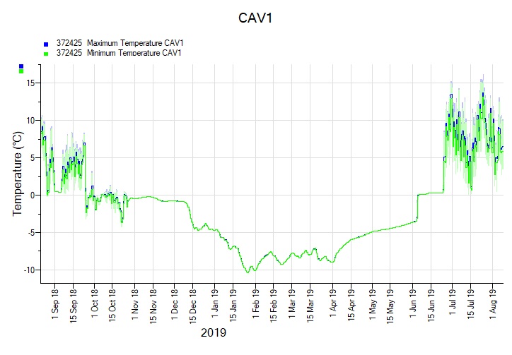
Fig. 4 - Esempio di andamento annuale della temperatura del terreno (GST) registrata da un data logger.
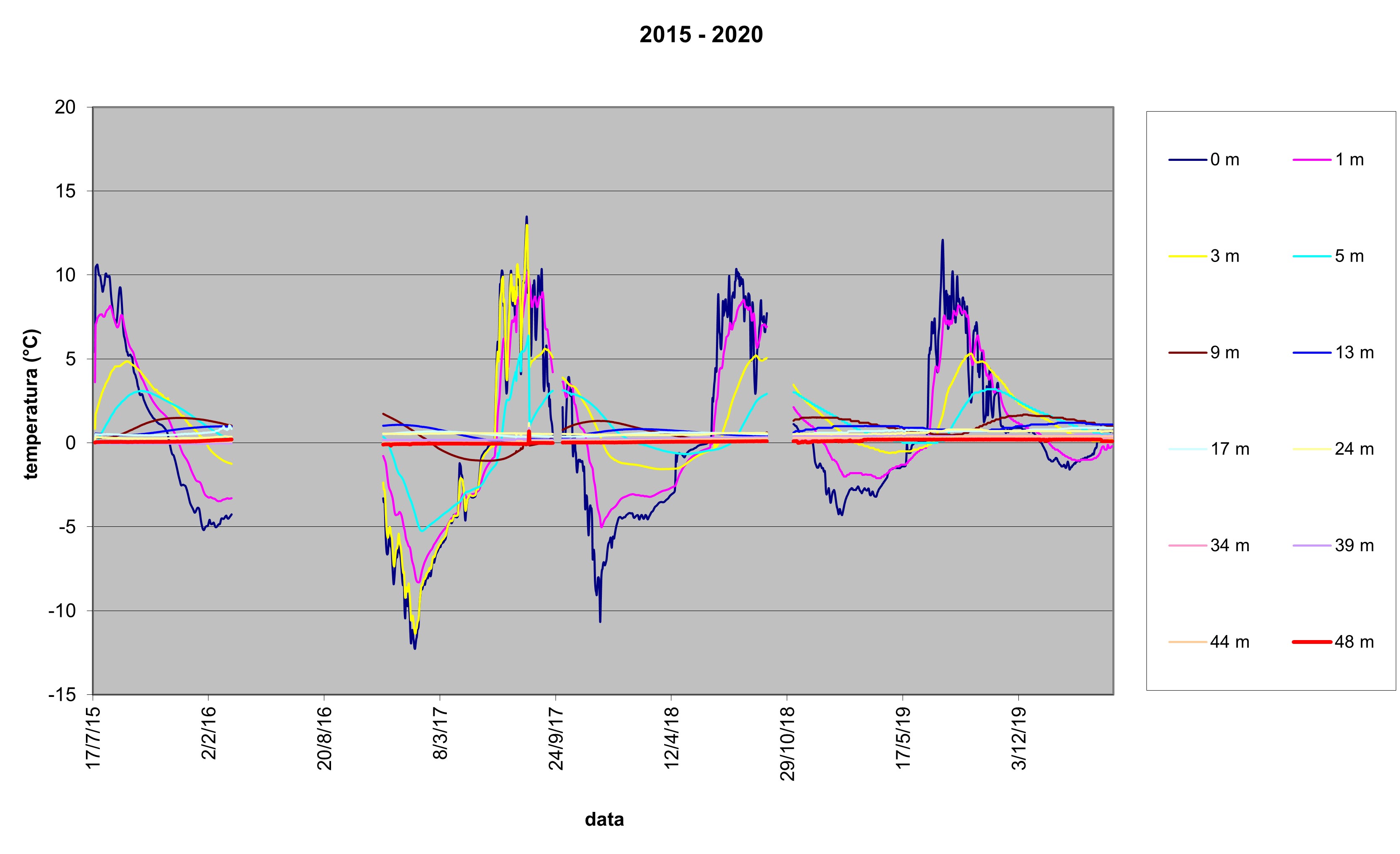
Fig. 5 - Grafico della temperatura a varie profondità nel foro in roccia tra il 2015 e il 2019. Sono rappresentati i sensori a varie profondità dal p.c.: 0 m, 1 m, 3 m, 5 m, 9 m, 13 m, 17 m, 24 m, 34 m, 39 m, 44 m, 48 m.
Given the presence of rock glaciers in the study area and in particular of active rock glaciers (i.e. containing permafrost and endowed with movement) since 2019, a monitoring of surface displacements on the rock glacier Cima di Pontevecchio has started (Fig. 1, Fig. 6), through the installation of a network of geodetic strongholds.

The data of the main weather instruments installed at the station can be consulted on the Meteotrentino website - on the page "Automatic Nivometers" page